


Solution Overview
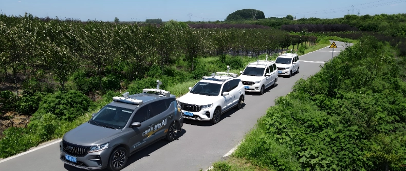
This solution integrates high-definition cameras, LiDAR, and high-precision positioning equipment into an onboard platform, and combines edge computing and cloud-based deep learning algorithms to achieve efficient collection, automatic extraction, and centimeter-level positioning of road assets (road surface, signs, guardrails, markings, light poles, etc.).
The system supports outputting standardized results that can be used in GIS, from raw images to structured asset lists, meeting the needs of various application scenarios such as daily road maintenance, asset inventory, risk assessment, and digital twins.
Application scenarios
Original technology enables business and services


Core Values
To achieve "one map across the entire domain, integrated business operations, and intelligent decision-making," and comprehensively improve the efficiency of industry governance.
-
"Clear Visibility" - Asset Transparency
Establish a digital ledger with "one map for overall overview and one code for each item" to make the quantity, location, status, and history of all assets clear at a glance, achieving 100% clarity of the bottom line.
-
"Meticulous Management" - Scientific Maintenance
Transform passive emergency response into proactive early warning and predictive maintenance, optimize resource allocation, extend asset lifespan, and significantly reduce total life cycle costs.
-
"Accurate Judgment" - Data-Driven Decision Making
It provides powerful data analysis and simulation capabilities, making decision-making processes such as maintenance planning, budgeting, and performance evaluation more data-driven, accurate, and efficient.
-
"Under control" - Operational collaboration
Streamline internal management processes to enable online collaboration across departments and business units, thereby improving management efficiency and execution from problem discovery to closed-loop resolution.
Application Cases
-
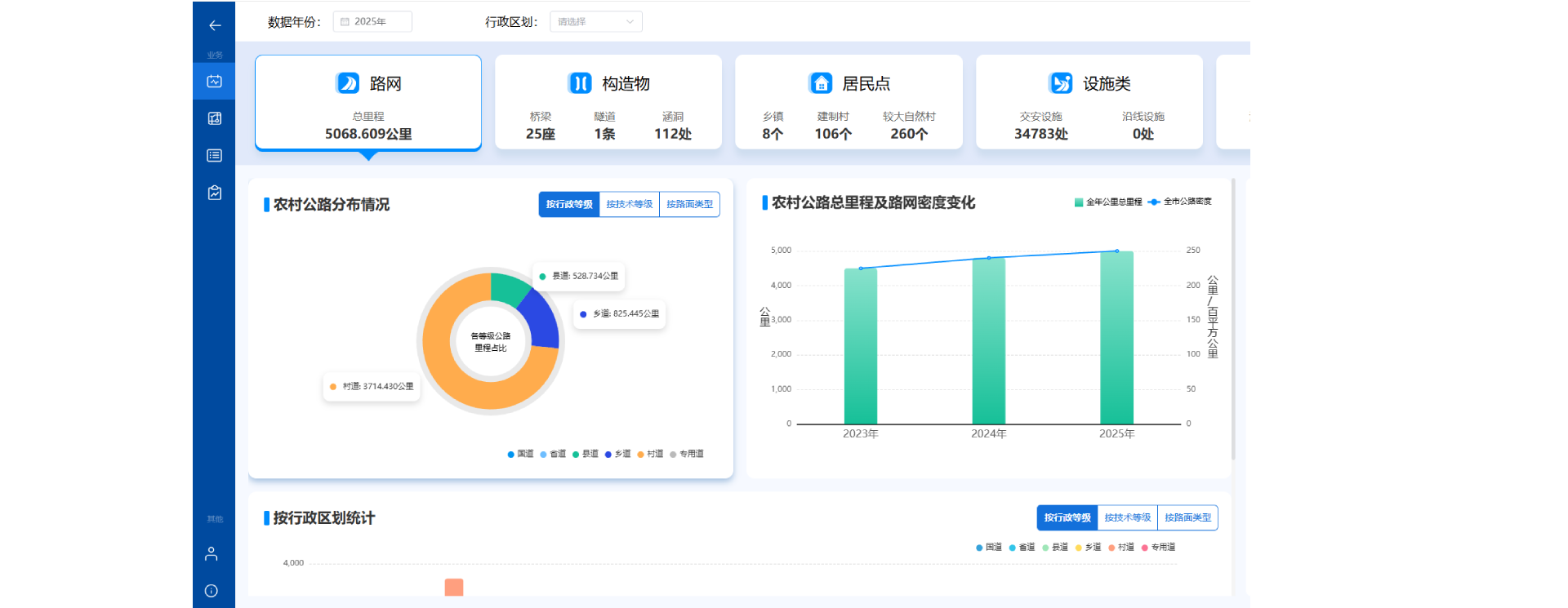
Hefei Rural Road Automated Detection and Basic Data Survey and Update Service
To thoroughly implement the spirit of the "Four Good Rural Roads" construction initiative and actively respond to the provincial pilot requirements of "One Road, One File" for rural roads, this key measure aims to facilitate the digital and refined transformation of rural road management in Hefei. Our company provided the Hefei Municipal Highway Management Service Center with a systematic and intelligent automated detection and basic data survey and update service for rural roads. By integrating high-precision sensors, artificial intelligence analysis, and big data platform technology, a comprehensive and traceable digital "check-up" was conducted on approximately 18,800 kilometers of rural roads throughout the city. This successfully established a city-wide, up-to-date, and scientifically sound rural road basic data resource database, setting a new benchmark for the digital transformation of rural road infrastructure in the province and even the country.
-

Wuhu City Rural Road Safety Hazard Investigation and Basic Data Verification Service
Focusing on ensuring safe passage and precise data management on rural roads, our company deeply participated in and assisted the Wuhu Municipal Highway Management and Service Center in successfully conducting a city-wide investigation of safety hazards and verification of basic data on rural roads. This work employed integrated air-ground-space survey technology, combined with on-site verification by a professional team, to comprehensively screen and accurately verify the roadbed, pavement, bridges, tunnels, culverts, traffic safety facilities, and high-risk points along rural roads within Wuhu City. The project established a closed-loop service system integrating hazard identification, risk assessment, and data updates, aiming to solidify the data foundation for rural road safety management in Wuhu and enhance proactive prevention capabilities.
-

Fuyang City Rural Road Basic Data Survey and Update Service
To thoroughly implement the national strategic plan for "Four Good Rural Roads" and "Digital Transformation of Highways," our company successfully won the bid and implemented the Fuyang City Rural Road Basic Data Survey and Update Project. As one of the three core pilot projects for the Ministry of Transport's "One Road, One File" information system in Anhui Province, this project aims to thoroughly understand the asset base of rural roads in Fuyang City through a comprehensive, traceable, and precise data census. It will construct a comprehensive rural road basic data resource database that meets the standards of the Ministry and the province, providing solid support for the aggregation of the province's "One Road, One File" data foundation and setting a model for the digital transformation of highways at the prefecture-level city level.